Fuel Measuring Systems- Regulated Power Source

Fuel Measuring Systems-Regulated Power Source


In most resistive type fuel qty. systems the aircrafts own power source (14 VDC or 28VDC) is used as the power for the quantity system. While the aircraft power is reasonably well regulated it is not a precise regulation, hence the first negative for resistive systems. Aircraft power can vary from approximately 12.6 volts up to 17 volts on a nominally 14 volt aircraft. On a 28 volt aircraft the power supply can vary from 24 volts up to 31 volts. The aforementioned variances are under normal operating conditions, if the power supply is experiencing technical problems then the variance can be significantly more.


Stay tuned for upcoming Blogs

Overview of Resistive Type Fuel Qty. Measuring Systems

Overview of Resistive Type Fuel Qty. Measuring System


The Resistive Type Fuel Quantity measuring system utilizes a variable resistive element in order to vary a precise electrical DC voltage based on the quantity of fuel in the fuel tank. The varying electrical signal, in turn, is used to drive the pointer on a fuel quantity indicator in a manner which is proportional to the amount of fuel in the tank, thereby visibly indicating remaining fuel quantity to the pilot.

The typical components in this type of system include the following:

a) Regulated DC Power Source
b) Tank Unit (Fuel Qty Sender, Fuel Probe)
c)  Indicator

Stay tuned to the TGH Aviation for additional information pertaining to these components


Stay tuned for upcoming Blogs

General Overview Fuel Measuring Systems

General Overview Fuel Flow Systems


The purpose of the Fuel Quantity Measuring System is to provide the pilot with a visual representation of the amount of useable fuel which is currently being held within the aircrafts fuel tanks.

There are two basic methods of providing this measurement:

Resistive Type Measuring Systems

Capacitive Type Measuring Systems

Both of these systems provide fuel quantity information by varying a precisely controlled electrical signal. However the method of varying that signal is considerably different between the two. In general, while resistive type systems are reasonably accurate and reliable they do not provide the high level precision and extended long term reliability that is provided by the capacitive type system. As a result, in modern aircraft, resistive systems are typically relegated to lower cost, lower performance aircraft while higher cost, and higher performance aircraft will almost always utilize the capacitive systems.

This training document will provide a general knowledge about both of these systems without going too deeply into the engineering and technical aspects of either system. This document is not intended to provide technical training at a level that would permit the student to perform repairs or maintenance on this system but rather is intended to provide a general knowledge of those systems at a level required by a Sales or Marketing person. Therefore only following subjects will be addressed:

a) A General Theory of System Operation
b)Components of the system
c) System pros and cons
d) Typical failure modes
e) Typical end users
f) Common manufacturers


Stay tuned for upcoming Blogs

Frequently Asked Altimeter Questions

Frequently Asked Altimeter Questions


The pointers on my altimeter are very jumpy and stick sometimes.
What is wrong?

The altimeter is exposed to the outside atmosphere. This includes all of the dirt and dust present in that atmosphere. Dirt and dust will get into the gears and cause them to stick and bind, the vibration from the aircraft will help the gears to overcome this problem but they will be very jumpy and become worse as the unit gets older. This unit needs an overhaul.


Can I convert my milli-bar altimeter to InHg or vice versa?

Yes, altimeter dials can be converted, provided that the manufacturer has published a procedure for doing so. If there are no published, FAA Approved, procedures then, no, this modification cannot be accomplished.


How often does my altimeter need to be calibrated?

The FAA requires that the aircraft static system be tested and certified biannually. The altimeter is a part of that system.


The altimeter ID plate says that it is a 35,000 Ft. altimeter, but the repair shop that overhauled my altimeter marked the unit as being certified to 30,000 Ft. Why the difference?

As altimeters get older and the parts wear the unit will become inaccurate at the higher end of its range. This does not mean that the altimeter can no longer be used; it just has to be used at the lower altitude. Therefore, it will be sold only to customers who request a lower altitude unit, typically general aviation.


What is a “car” altimeter?

Sometimes, if a unit is so old and worn that it can no longer be used in an aircraft then these units are sold at a discounted price for use in other than aircraft, typically people will use them in motor homes, cars, and boats.


Along with my altimeter, I received a correction card. What is that?

Altitude is a non-linear function.  It is impossible to calibrate an altimeter to be absolutely accurate at all altitudes. Therefore, a certain amount of error is allowable. The correction card advises the users of the amount of error in a particular altimeter. As each altimeter will have its own characteristics, the error card is identified with the unit’s serial number.


What is a TSO?

TSO stands for Technical Standard Order. This is an FAA document, which defines how a specific type of instrument should work in order to be considered airworthy. Altimeters manufactured by the following companies typically are manufactured to TSO standards: United Instruments, Kollsman, Garwin, and Aerosonic. Altimeters manufactured by the following companies typically are not qualified to TSO specifications:UMA & Falcon. If an instrument is certified to a TSO, it must state such on the ID plate. If it does not state the TSO on the nameplate then you must assume that it is not qualified to the TSO.


What are the typical failure modes of an altimeter?

  1. Sticky/jumpy pointers
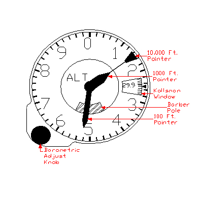
  2. Inability to properly adjust the Kollsman window
  3. Out of calibration
  4. Worn pivots and/or jewels
  5. “Oil-canning” of the aneroid


How to Read a 3 Pointer Altimeter

How to Read a 3 Pointer Altimeter

A three-pointer altimeter, as its name implies, has three different pointers on the front dial. They are the 100-foot pointer, the 1000-foot pointer, and the 10,000-foot pointer. The medium length pointer is the 100-foot pointer, the shortest pointer is the 1000-foot pointer, and the longest pointer is the 10,000-foot pointer. The altimeter dial has 10 major indices numbered 0 through 9. In between each major indice are 4 minor indices. The value of these indices is dependent on the pointer being read. When reading the 100-foot pointer each minor indice equals 20 feet, each major indice equals 100 feet. When reading the 1000-foot pointer each minor indice is equal to 200 feet, each major indice is equal to 1000 feet. When reading the 10,000-foot pointer each minor indice is equal to 2000 feet, each major indice is equal to 10,000 feet. The altimeter in figure 1 is indicating 11,520 feet and is read as follows:


The 10,000 foot pointer is past the 1 and not yet up to the

2 and so it is read as:                                                           1 x 10,000 = 10,000 +

The 1,000 foot pointer is past the 1 and not yet up to the

2 and so it is read as:                                                           1 x 1,000 = 1,000 +

The 100-foot pointer is 1 minor indice past the 5 and so

Therefore, it is read as:                                                        5.2 x 100 = 520

The indicated altitude is the sum of the pointers:                        11,520

barber_pole

Figure 1: Three-Pointer Altimeter

Understanding Altimeters

Understanding Altimeters


In its purest form, an altimeter is simply an absolute pressure gauge. This means that it is displaying the pressure being exerted by the atmosphere at its current location.

The earth is surrounded by an atmosphere. This atmosphere is the air that we breathe. The atmosphere is held in place by the earth’s gravity. The atmosphere has a specific weight. The weight of the atmosphere is approximately 14 pounds of weight for every square inch of earth when measured at sea level on an average day.

An accurate method of measuring this weight is to use a barometer. A barometer is a reservoir filled with mercury. The reservoir has two openings; one opening is exposed to the atmosphere and the other empties into a glass tube. The atmosphere pushes down on the mercury within the reservoir causing the mercury to fill up the glass tube. How far the mercury goes up into the glass tube is directly proportional to the weight of the atmosphere pushing it. This is why barometric pressure is normally expressed in terms of “Inches of Mercury (InHg)”.

At sea level, on an average day, the barometric pressure is 29.92 InHg. However, this will vary constantly depending on the weather. Stormy weather tends to pull the atmosphere away from the earth’s surface causing lower pressure. Hot, dry weather pushes the atmosphere down causing higher pressure.

The weight of the atmosphere also changes depending on altitude. The closer to sea level that you are, the more air there will be, consequently the atmosphere will weigh more. As you go higher in altitude, the less dense the atmosphere will be, therefore less weight or pressure is exerted. An altimeter measures this change in atmospheric weight as expressed in terms of pressure or feet of altitude.


All About Altimeters

All About Altimeters


General Information

The altimeter provides the basic function of indicating to the pilot the altitude of the aircraft above mean (average) sea level (MSL).  The indicator is normally a 31/8” size dial face with multiple pointers or a combination of pointers and counter drum. Location of this indicator is typically in the top row of instruments near the center of the instrument panel. In a standard “T” configuration panel the altimeter is just to the right of the attitude gyroscope.


Types of Altimeters

The various types of altimeters include:

  1. Three pointer altimeter
  2. Counter Drum Altimeter
  3. Encoding Altimeter

Typical altimeter ranges are:

  1. –1000 Ft. to +20,000 Ft.
  2. –1000 Ft. to +35,000 Ft.
  3. –1000 Ft. to +50,000 Ft.
  4. –1000 Ft. to +80,000 Ft.


Most general aviation altimeters will fall into the first two ranges. Ranges above 35,000 Ft. are typically corporate jets, commercial aircraft, and military aircraft.


Three Pointer Altimeter

The three-pointer altimeter is the most common type of instrument used in general aviation. It is named as such because it utilizes three pointers in order to display the current altitude. One pointer is used to display 100 Ft. increments. A second pointer is used to display 1000 Ft. increments and the third pointer displays 10,000 Ft. increments. The Technical Information Section of this document provides instructions on how to properly read a three-pointer altimeter.


Counter Drum Altimeter

The counter-drum altimeter is named as such because it displays altitude utilizing a single pointer and a rotating drum that displays digits. The drum displays ten thousand and one thousand foot increments. The pointer displays from 0 to 999 feet.


Encoding Altimeter

An encoding altimeter can be of either the three-pointer or counter drum type of altimeter with an encoding module built into it. The encoding module takes the altitude information and converts that data into a digital code. This code is then sent via a set of wires to the aircraft transponder. A transponder is a radio device that reports the aircraft altitude to ground control radar.


Blind Encoder

The blind encoder is a very special type of altimeter. This unit has no dial or read out that is visible to the user. It has only an electronic output to the aircraft transponder. The use of a standard altimeter in conjunction with a blind encoder is often more economical than purchasing an encoding altimeter.


Photo Lineup